Mount Cardigan - 3,155'
Hike Statistics
Total Distance: 5.9 miles
Elevation Gain: 1,910 feet
Hiking Time: 4 hours, 25 minutes
Difficulty: Moderate
Season: Spring
Hiking this peak in winter? Click here!
Hike date: 05/15/2021
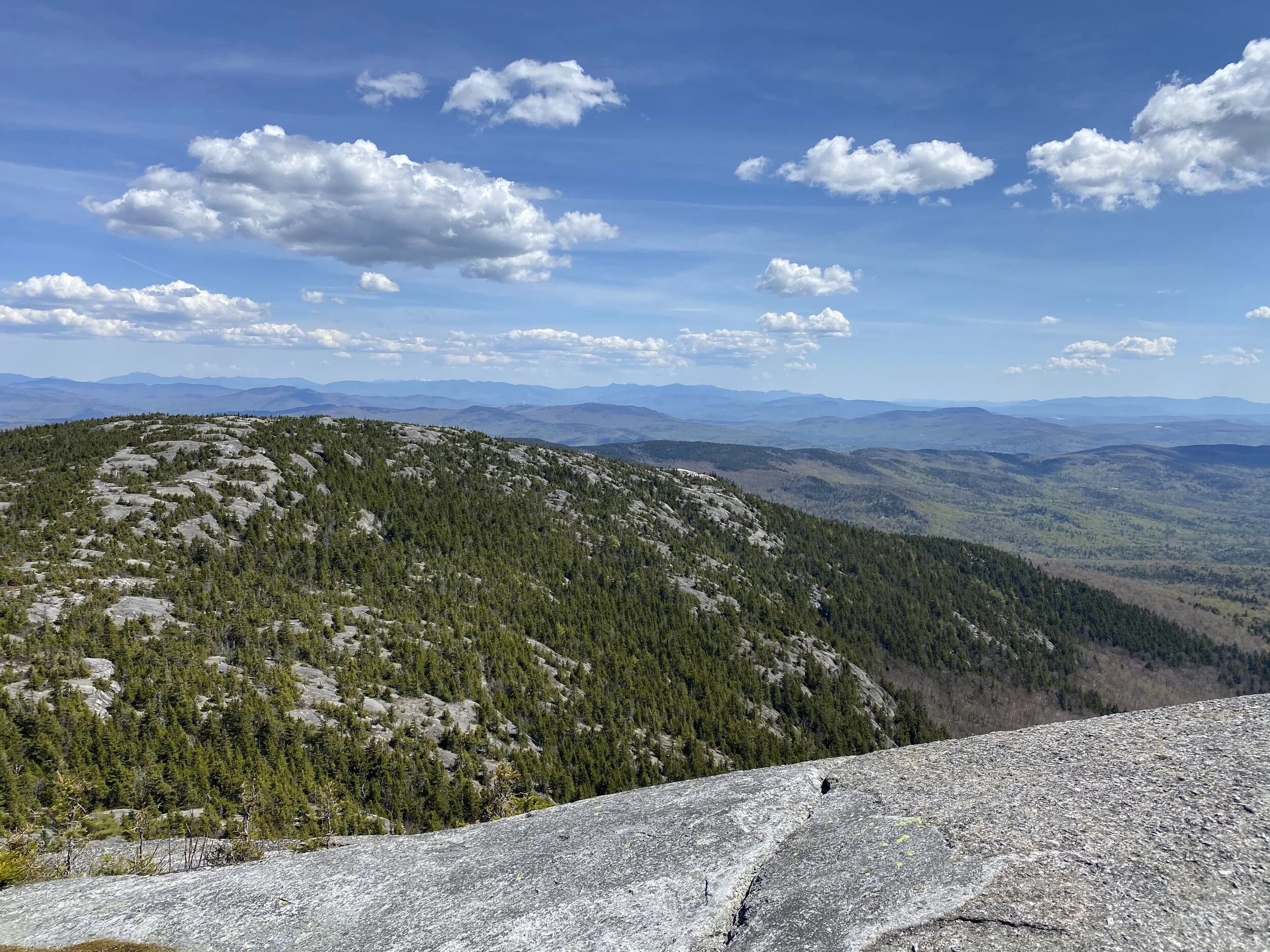
Description: Mount Cardigan has one of the best views in the western part of New Hampshire due to its bare summit that offers panoramic 360 degree views. There is also a fire tower at the summit! From the ledges of the summit, the best views are to the north, with Firescrew (a Cardigan subpeak) immediately visible and many peaks of the White Mountains further beyond (you’ll be able to see Mount Moosilauke looming behind Firescrew, Mount Lafayette and the rest of Franconia Ridge, the very distant Presidential Range, the pointy Tripyramids, and countless other 4,000 footers and smaller peaks). Looking south from the summit affords views towards other Cardigan subpeaks (like Rimrock and Orange), Mount Kearsarge, a faint Mount Monadnock, and views into Vermont as you turn west.
Be sure to check out our YouTube video of our hike to Mount Cardigan which you can find here!
Trails Used: Ascend via the Manning Trail to the summit of Firescrew. From there, take the Mowglis Trail (South) to reach the summit of Mount Cardigan. Descend via the Clark Trail to the Cathedral Forest Trail to the Holt Trail to get back on the Manning Trail. Continue on Manning Trail back to the trailhead.
Trail Summary: This counter-clockwise loop will first take you to Cardigan’s northern subpeak, Firescrew, before heading over to Mount Cardigan. It is a very scenic route, with lots of ledges that have incredible views! Parking for this hike is at the AMC Cardigan Lodge; we arrived at the trailhead just after 8 am on a beautiful Saturday and got one of the last spots in the lot! Despite the “No Parking” signs along the road, there was a long line of cars parked on the road when we returned. Overall, this is a moderate hike with good terrain and decent grades; there are a number of steeper slab sections that add a bit of spice to the hike!
You’ll start out on the Manning Trail, which is accessed at the end of the parking lot near the lodge. As you head into the woods, you’ll pass a number of campsites; we really want to come back some time and camp here as they looked really nice! The half mile section of the Manning Trail to the first junction with the Holt Trail is basically flat - a nice warm up! At the junction, the trail heads into the woods and starts climbing more moderately; the terrain becomes more rocky mixed with roots. There are many junctions with backcountry ski trails along the way, and we thought to ourselves it must be pretty awesome to ski here! As you make your way up the trail, you’ll eventually encounter one large scramble that has a nice view toward Mount Cardigan after it. We really enjoyed the section of trail beyond this point because the woods were covered in moss and there were tons of HUGE boulders along the trail. After the boulder section, the trail gets rougher and steeper as you find yourself starting to scramble up exposed slab. There are tons of ledges along this ridge with awesome views to the north (which also make for great spots to take a break!). Continue winding up the slab and you’ll soon find yourself at the summit of Firescrew with Mount Cardigan straight ahead. This is also where the junction with the Mowglis Trail is. From the trailhead to this junction, you’ll have hiked roughly 2.6 miles and gained about 1,600 feet of elevation so far.
The beginning of the Manning Trail, a perfect warm up!
As you enter the woods, the Manning Trail climbs more moderately and is rocky
One of the first scrambles that will be encountered on the Manning Trail
Mount Cardigan peaking out from a viewpoint after the scramble
Steeper and rockier conditions as you get closer to Firescrew can be expected
Emily gazing up at a boulder along the trail; it is massive!
There are plenty of ledges that make for good breaks and photo opportunities!
Keep an eye on the cairns as you make your way up the slab sections
From Firescrew looking towards Mount Cardigan, our next stop!
After a short break on Firescrew, it was on towards Mount Cardigan! At the junction with the Mowglis Trail, you’ll want to take a left, heading towards the south direction of the trail. In this short section between the two peaks, which is roughly half a mile long, you’ll lose about 100 feet of elevation before gaining about 200 feet of elevation as you make the final push towards the summit of Mount Cardigan. It’s fairly easy hiking in this part, except for the final climb up to the summit cone where you’ll head up steep slab. Before you know it, you’ll see the fire tower peaking out in front of you and you’ll have reached the summit area with its wide open views. As mentioned in the description above, you’ll have views of the Cardigan subpeaks, the White Mountains to the north, Vermont and its peaks to the west, and a seemingly endless amount of smaller peaks. You can’t climb into the actual fire tower, but you can go part way up the ladder if you desire. The sun was shining, so we laid out on the smooth rock and soaked up some Vitamin D (which also led to us getting sunburned - don’t forget the sunscreen on these crystal clear days!).
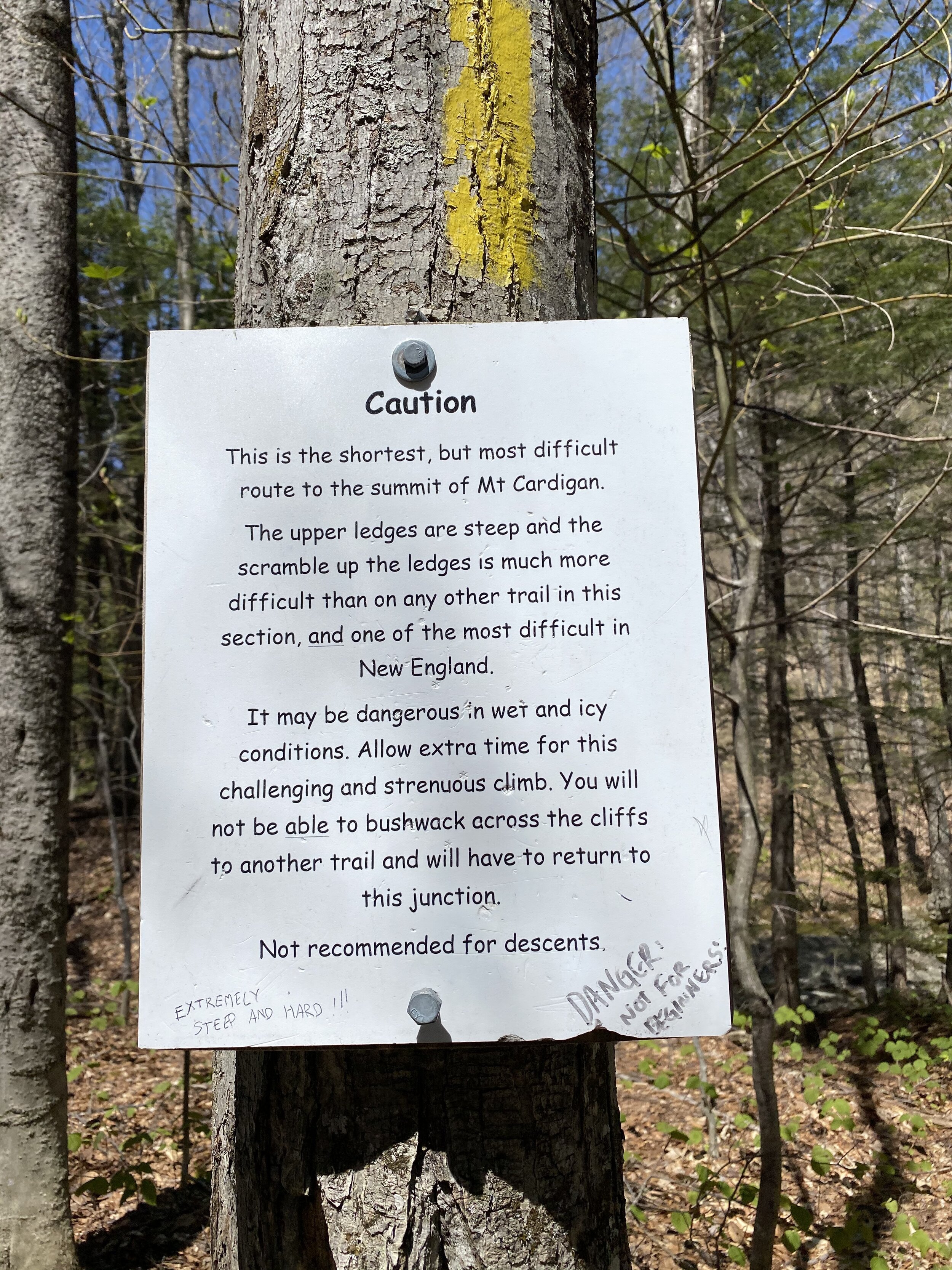
After a long break at the top, we got ready to make our descent down back to the start. You’ll want to head south past the fire tower and make your way down the wide ledges on the white blazed Clark Trail (which bears left coming down from the summit). The descent starts out easy, then becomes steeper as you make your way down the summit slab. Shortly, you’ll pass by an old cabin, presumably used for those who manned the fire tower. Beyond here, Clark Trail eases up and offers a more moderate descent as you enter back into the woods. You’ll pass a nice viewpoint on the left; after this, the trail is less rocky and offers a great gradual descent. At the junction with Cathedral Forest Trail, we took a left and headed down into some nice open woods with solid trails. After some time, you will find yourself at “Grand Junction”, an area where several trails intersect. At this junction, you’ll want to hop on the Holt Trail. It’s a good thing we are going down and not up, as the upper portion of the Holt Trail makes a very steep ascent to the summit; it’s marked with a warning sign… maybe we’ll try it next time! After maybe 100 feet on the Holt Trail, there is a nice trail-side waterfall that you can make a quick downhill trip to check out. Continuing back, you’ll eventually come to another junction where you can take the Manning Trail back to your car. From Grand Junction to the trailhead, it’s a quick and easy 1.2 mile descent back to the lodge.
We really loved this loop! The trails were very well maintained and a nice mix of moderate to challenging terrain, the views were incredible, and the woods were very pretty. We will definitely be coming back to this area again to hike the many other trails that are here!
Heading up some steep slab as we make the final push towards Mount Cardigan
Looking up the steep slab that we just descended coming off the summit
There are easy grades and terrain as you make your way down the mountain
A perfect summit kiss with an amazing backdrop!
The old cabin we assume was used for those working the fire tower
A warning to those attempting the Holt Trail… it is no joke!
Heading south off the summit towards the Clark Trail on the wide ledges
One last viewpoint as you make your way down the Clark Trail
Grand Junction, an area where several trails intersect with one another
The small trail side waterfall just after Grand Junction. We were very tempted to take a swim!
We love a nice bridge to make a river crossing easy! The water was still very cold, but felt refreshing to splash on us!
Alternative routes:
We have not yet done any alternative routes to the summit of Mount Cardigan. This page will be updated once we have!
Hiking Mount Cardigan in the winter
We have not yet climbed Mount Cardigan in the winter, but once we do, we will update this page with our full report!
Questions? Comments? Want to share your take on this hike? Get in touch with us using the contact page!


As experienced hikers, we always make sure that we are hiking with The Ten Essentials which include navigation, a headlamp, sun protection, first aid, a knife, shelter, extra food, water and clothes. Overtime, we have discovered some items that we always bring on our hikes and consider them to be our personal, expanded ten essentials.