NORTH (3,053') & SOUTH (2,939') DOUBLEHEAD LOOP HIKE
Hike Statistics
Total Distance: 3.7 miles
Elevation Gain: 1,650 feet
Hiking Time: 4 hours, 45 minutes
Difficulty: Moderate
Season: Fall
Hiking this peak in winter? Click here!

Hike date: 10/10/2020
Description: Originally, only North Doublehead was on the 52 With a View list, but since the peak has lost a lot of its view, it has been combined with South Doublehead (which has great outlooks) and is now treated as a loop to count. From North Doublehead, you can see east towards Mountain Pond and deep into Maine, as well as glimpses of the Presidential Range to the west. From South Doublehead, you get to enjoy a wide variety of views. Some of the most prominent views include the distant Lakes Region, Mount Carrigain, Mount Resolution, Mount Stairs, Black Mountain, the Presidential Range, the Wildcats, the Carters (and Carter Notch), and the village of Jackson!
Trails Used: Ascend via the Doublehead Ski Trail to the summit of North Doublehead. From the summit, take the Old Path to the New Path towards the summit of South Doublehead. From the summit, head back down the New Path to the junction and descend via the Old Path and Doublehead Ski Trail.
Trail Summary: The trailhead for this hike is in a parking area on the left side of Dundee Road. Something to watch out for: we did get a bit confused because our GPS took us to an area on a private road which is the location of the old parking area. You’ll see the signs that say no parking and guide you to the new parking area just up the road! Though both peaks can be hiked individually, it makes the most sense to do them together since they’re right next to each other (especially now that you need to do both for them to count for the 52 WAV). We opted to take the ski trail up to North Doublehead, do the short in and out to South Doublehead, and then headed down the Old Path to form a nice loop.
From the trailhead, the Doublehead Ski Trail ascends easily until you reach a junction with Old Path on the right, roughly 0.6 miles from the start. This is where you’ll descend from, so for now stick to the left and continue up the ski trail. The trail is nice and wide (since it used to be a ski trail) and the footing is great and not very rocky most of the way up. After the junction, the trail becomes steadier as the grade steepens a bit. There were a few steeper sections, and on some of the curvy sections we wondered how skiers tackled them given the terrain! As you approach the summit, the woods shift from open forest to dense evergreen, which was a nice vibe change for us. The trail also becomes rockier on the final push towards the summit. After hiking 1.2 miles from the previous junction, you’ll find yourself at the wooded summit of North Doublehead and in front of the Doublehead Cabin. The cabin looks really cool, but it was unfortunately locked (most likely due to COVID) so we couldn’t check out the inside. It definitely looks like it would be super cozy in the winter! From the cabin, there is a limited view towards the Presidential Range through a clearing in the trees. The main viewpoint on North Doublehead is down a short side path to the side of the privy behind the cabin. From this viewpoint, you can see Mountain Pond and several smaller peaks along with views deep into the western part of Maine. After a snack and enjoying the view, it was time to make our way towards South Doublehead!

Getting ready to start our trip up to the Doubleheads!

The ski trail starts out at a very easy grade until the first junction

Junction with Old Path, you’ll descend from here later! Stay left on the ski trail for now

The ski trail is starting to get a bit steeper now!

The ski trail becomes a bit rockier, but also more moderate, as you near the summit

Doublehead Cabin! Unfortunately it was locked so we couldn’t go inside

Emily got caught admiring the view towards the Presidential Range

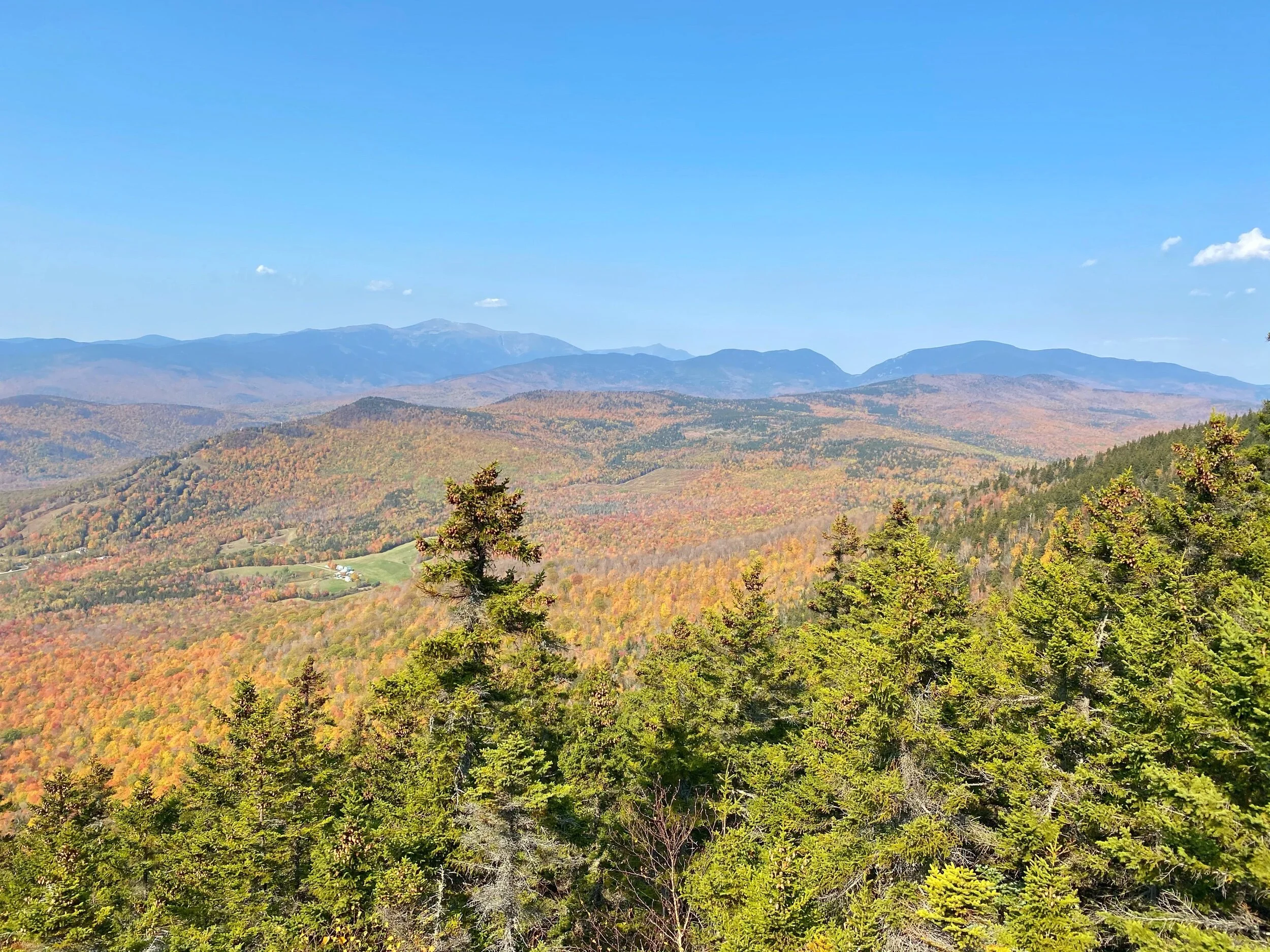
Looking toward Mountain Pond and some smaller peaks and into western Maine

Time to head off towards South Doublehead now!
From the summit of North Doublehead, it’s a quick but steep and rough descent on Old Path over rocky terrain. Pay attention for a small cairn on the right side of the trail while you’re heading down (GPS coordinates are N44.16720, W71.13090)! This marks a herd path that descends a bit to a nice open ledge with excellent views (much better than the summit)! From this outlook, you can see some of the smaller peaks in the area to the southwest, parts of the Sandwich Range, several very distant 4,000 footers (like the Tripyramids, Tecumseh, Osceola, Carrigain, parts of Franconia Ridge, South Twin, and parts of the Willey Range) and several 52 WAV peaks (Stairs, Resolution, Iron, and Black Mountain) to the west, and the southern end of the Presidential Range to the northwest! You’ll also get to see the village of Jackson from above. It is definitely worth the small detour! Once back on the main trail and roughly 0.3 miles from the summit of North Doublehead, you’ll come to a junction with New Path in the col between the two Doubleheads. From here, take a quick short climb to reach the South Doublehead summit and outlook (roughly 0.2 miles; 150 feet of elevation gain). You’ll see a well traveled side path on your right that takes you to the open ledges that offer an expansive vista of views. You’ll get pretty much the same view as from the previous ledge, BUT this one is much wider so you can see further south towards the Lakes Region and further north to see the whole Presidential Range as well as the Wildcats and Carters (along with the very well defined Carter Notch). We always enjoy being able to pinpoint the various peaks we’ve hiked from viewpoints!
If you’re up for it, continue along the New Path for a short bit (at the junction you come to, follow the sign towards South Doublehead) and you’ll come to another viewpoint where there is a large cairn. Here, the view is a bit more restricted because of the trees, but you can see Kearsarge North and the Ossipees to the south, several 52 WAV peaks (Shelburne Moriah, Success, the Baldfaces, and Eastman) to the north, and North Doublehead right in front of you. After enjoying some more views, retrace your steps all the way back to the junction with New Path and Old Path in between North and South Doublehead. At this junction, you’ll start your descent on the Old Path. The hike down is steep pretty much the whole way, though it’s not super rocky. We were saying how we want to come back in the winter because this would definitely be a gnarly trail to sled the whole way down! In 0.6 miles, you’ll reach the junction with the ski trail (where you were earlier at the start of the hike). Take a left onto the ski trail and you’ll be back to the parking lot in no time!

Coming off of North Doublehead is a bit steep as you head into the col

Keep an eye out for this cairn on the right side of the trail! It’ll lead you to the ledges

The view from the ledges off the herd path! Still some good fall colors!

Looking towards South Doublehead from the ledges… our next stop!
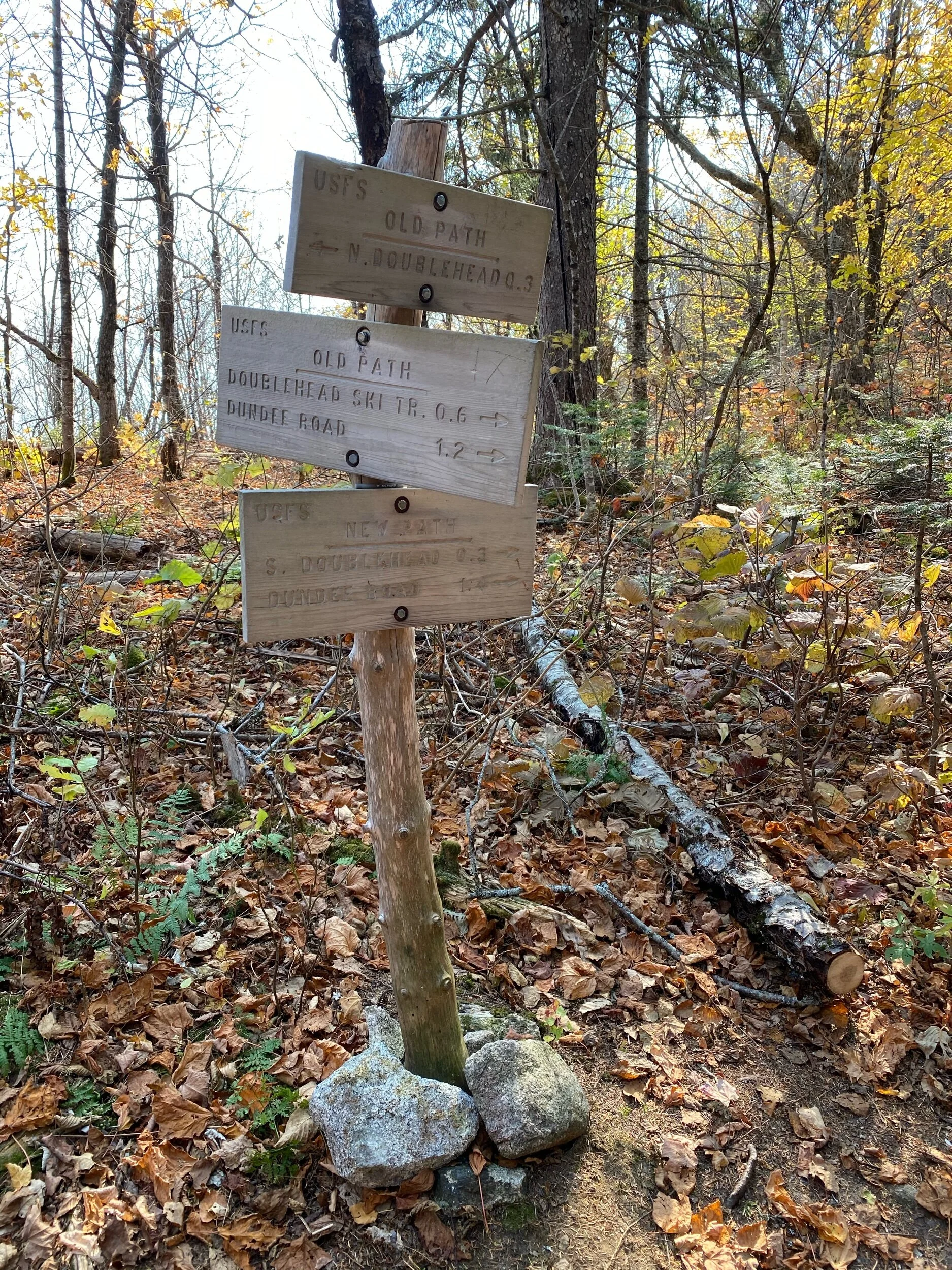
The junction with Old Path and New Path. Sign looks to have been replaced recently

From the main viewpoint on South looking towards Carter Notch and the Presi’s
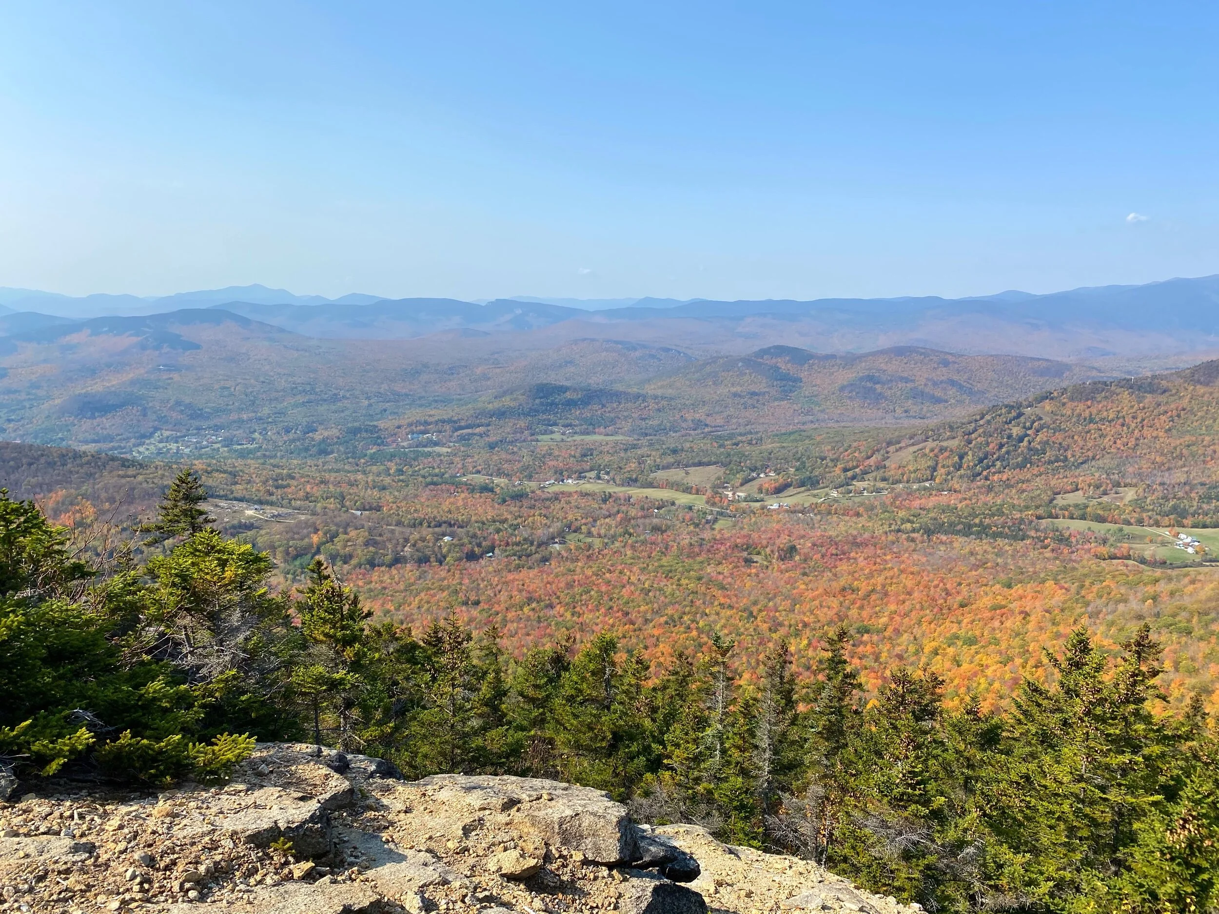
Several 4k’s and 52WAV peaks are visible as well. Great foliage!

A close up of Black Mountain and the foliage in the valley

The cairn at the other viewpoint a bit further from South Doublehead

Looking south towards Kearsarge North and the Ossipees

Looking north towards North Doublehead and the Baldfaces

Heading down the steep Old Path! Luckily the terrain is not too rough
Alternative routes:
We have not yet done any alternative routes to the summits of North & South Doublehead. This page will be updated once we have!
Hiking North & South Doublehead in the winter

We have not yet climbed North & South Doublehead in the winter, but once we do, we will update this page with our full report!
Questions? Comments? Want to share your take on this hike? Get in touch with us using the contact page!


As experienced hikers, we always make sure that we are hiking with The Ten Essentials which include navigation, a headlamp, sun protection, first aid, a knife, shelter, extra food, water and clothes. Overtime, we have discovered some items that we always bring on our hikes and consider them to be our personal, expanded ten essentials.